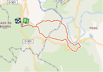
![](/images/other/stat-length.png)
![Randonnée Marche Les Vans - Igressiere-lestong-hermite - Photo](https://media.geolcdn.com/t/1900/400/ext.pjpeg?maxdim=2&url=https%3A%2F%2Fmedia.geolcdn.com%2Ff%2F451e21ac-d888-40dc-b9c3-47ee22e86b9d.jpg)
Igressiere-lestong-hermite
ganinette
Utilisateur
![Longueur](/images/other/stat-length.png)
Longueur
8 km
![Altitude max](https://static1.geolcdn.com/siteimages/upload/files/1508320355ic_sort_altitude_max_24dp.png)
Altitude max
251 m
![Dénivelé positif](https://static1.geolcdn.com/siteimages/upload/files/1508320355ic_sort_den_pos_24dp.png)
Dénivelé positif
174 m
![Km-Effort](/images/other/stat-length.png)
Km-Effort
10,3 km
![Altitude min](https://static1.geolcdn.com/siteimages/upload/files/1508320355ic_sort_altitude_min_24dp.png)
Altitude min
155 m
![Dénivelé négatif](https://static1.geolcdn.com/siteimages/upload/files/1508320355ic_sort_den_neg_24dp.png)
Dénivelé négatif
175 m
![Boucle](https://static1.geolcdn.com/siteimages/upload/files/16400158638029165_repeat_loop_refresh_sync_direction_icon.png)
Boucle
Oui
Date de création :
2020-09-26 11:30:20.037
Dernière modification :
2020-09-29 07:22:27.099
![Marche](https://static1.geolcdn.com/sitytour/trail-icons/101.png)
2h33
Difficulté : Moyen
![Scannez ce code QR pour ouvrir la randonnée dans l'application SityTrail](https://capi.geolives.com/qq0zvz2zws4bq2lad0pu/sitytour/trails/2562046/qr.png?size=200)
Application GPS de randonnée GRATUITE
À propos
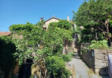
Randonnée Marche de 8 km à découvrir à Auvergne-Rhône-Alpes, Ardèche, Les Vans. Cette randonnée est proposée par ganinette.
Description
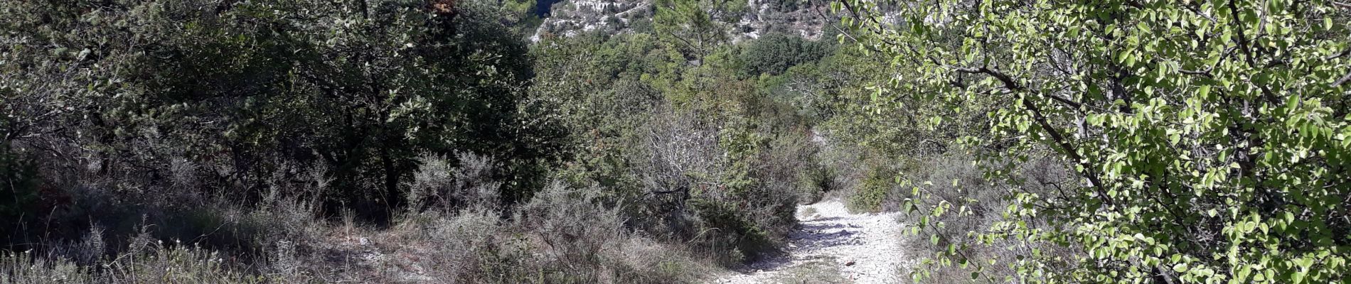
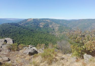
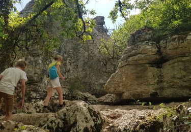
une parti de la rando longe les corniches du chassezac avec un très beau
point de vue.
Randonneurs sujet au vertige s'abtenir.
Localisation
Pays :
France
Région :
Auvergne-Rhône-Alpes
Département/Province :
Ardèche
Commune :
Les Vans
Localité :
Chassagnes
Départ:(Dec)
Départ:(UTM)
592738 ; 4917088 (31T) N.
Commentaires
Randonnées à proximité
![Randonnée Marche Banne - Autour de Banne - Photo](https://media.geolcdn.com/t/375/260/ext.jpg?maxdim=2&url=https%3A%2F%2Fmedia.geolcdn.com%2Ff%2F0d756104-e1b5-4f2e-b3d0-c252da0f965f.jpg)
![Marche Marche](https://static1.geolcdn.com/sitytour/trail-icons/101.png)
Autour de Banne
Marche
Difficile
Banne,
Auvergne-Rhône-Alpes,
Ardèche,
France
![](/images/other/stat-length.png)
19,8 km | 28 km-effort
5h 46min
![](https://static1.geolcdn.com/siteimages/upload/files/16400158638029165_repeat_loop_refresh_sync_direction_icon.png)
Oui
![Randonnée Marche Les Vans - Vallée de la Gagnière - Photo](https://media.geolcdn.com/t/375/260/ext.jpg?maxdim=2&url=https%3A%2F%2Fmedia.geolcdn.com%2Ff%2F71917047-d88c-4c64-a341-02552bb982e0.jpg)
![Marche Marche](https://static1.geolcdn.com/sitytour/trail-icons/101.png)
Vallée de la Gagnière
Marche
Difficile
Les Vans,
Auvergne-Rhône-Alpes,
Ardèche,
France
![](/images/other/stat-length.png)
22 km | 35 km-effort
20h 27min
![](https://static1.geolcdn.com/siteimages/upload/files/16400158638029165_repeat_loop_refresh_sync_direction_icon.png)
Non
![Randonnée Marche Les Vans - Vallée de la Gagniére - Photo](https://media.geolcdn.com/t/375/260/ext.jpg?maxdim=2&url=https%3A%2F%2Fmedia.geolcdn.com%2Ff%2F1508dc5f-9f29-4533-9f11-f708e0c455a3.jpg)
![Marche Marche](https://static1.geolcdn.com/sitytour/trail-icons/101.png)
Vallée de la Gagniére
Marche
Difficile
Les Vans,
Auvergne-Rhône-Alpes,
Ardèche,
France
![](/images/other/stat-length.png)
22 km | 35 km-effort
7h 22min
![](https://static1.geolcdn.com/siteimages/upload/files/16400158638029165_repeat_loop_refresh_sync_direction_icon.png)
Non
![Randonnée V.T.T. Les Vans - Vans banne Berrias retour - Photo](https://media.geolcdn.com/t/375/260/ext.jpg?maxdim=2&url=https%3A%2F%2Fstatic1.geolcdn.com%2Fsiteimages%2Fupload%2Ffiles%2F1524743154velo.jpg)
![V.T.T. V.T.T.](https://static1.geolcdn.com/sitytour/trail-icons/202.png)
Vans banne Berrias retour
V.T.T.
Moyen
(1)
Les Vans,
Auvergne-Rhône-Alpes,
Ardèche,
France
![](/images/other/stat-length.png)
23 km | 28 km-effort
2h 10min
![](https://static1.geolcdn.com/siteimages/upload/files/16400158638029165_repeat_loop_refresh_sync_direction_icon.png)
Non
![Randonnée Marche Les Vans - GRP Le Cévenol Brahic-Génolhac 32km - Photo](https://media.geolcdn.com/t/375/260/ext.jpg?maxdim=2&url=https%3A%2F%2Fmedia.geolcdn.com%2Ff%2Fd74c8751-f379-4bc1-a2c8-84f5f2d71730.jpg)
![Marche Marche](https://static1.geolcdn.com/sitytour/trail-icons/101.png)
GRP Le Cévenol Brahic-Génolhac 32km
Marche
Difficile
Les Vans,
Auvergne-Rhône-Alpes,
Ardèche,
France
![](/images/other/stat-length.png)
32 km | 50 km-effort
11h 28min
![](https://static1.geolcdn.com/siteimages/upload/files/16400158638029165_repeat_loop_refresh_sync_direction_icon.png)
Non
![Randonnée Marche Berrias-et-Casteljau - Wikiloc Bois de Paiolive (PVDB) - Photo](https://media.geolcdn.com/t/375/260/ext.jpg?maxdim=2&url=https%3A%2F%2Fmedia.geolcdn.com%2Ff%2F045714af-a6fd-44e6-8871-35194bcde521.jpg)
![Marche Marche](https://static1.geolcdn.com/sitytour/trail-icons/101.png)
Wikiloc Bois de Paiolive (PVDB)
Marche
Moyen
Berrias-et-Casteljau,
Auvergne-Rhône-Alpes,
Ardèche,
France
![](/images/other/stat-length.png)
9,9 km | 12,3 km-effort
4h 24min
![](https://static1.geolcdn.com/siteimages/upload/files/16400158638029165_repeat_loop_refresh_sync_direction_icon.png)
Oui
![Randonnée Marche Les Vans - Bois de Païolive - Photo](https://media.geolcdn.com/t/375/260/ext.jpg?maxdim=2&url=https%3A%2F%2Fservices.sitytrail.com%2FGeolivesWS%2FDownloadMedia.ashx%3FTrailID%3D372613%26Media%3Dfix__20141226114045.jpg)
![Marche Marche](https://static1.geolcdn.com/sitytour/trail-icons/101.png)
Bois de Païolive
Marche
Moyen
(1)
Les Vans,
Auvergne-Rhône-Alpes,
Ardèche,
France
![](/images/other/stat-length.png)
2,9 km | 3,3 km-effort
1h 33min
![](https://static1.geolcdn.com/siteimages/upload/files/16400158638029165_repeat_loop_refresh_sync_direction_icon.png)
Oui
![Randonnée Marche Berrias-et-Casteljau - paiolive - Photo](https://media.geolcdn.com/t/375/260/ext.jpg?maxdim=2&url=https%3A%2F%2Fstatic1.geolcdn.com%2Fsiteimages%2Fupload%2Ffiles%2F1553511878bg_sport_marche.png)
![Marche Marche](https://static1.geolcdn.com/sitytour/trail-icons/101.png)
paiolive
Marche
Très facile
(1)
Berrias-et-Casteljau,
Auvergne-Rhône-Alpes,
Ardèche,
France
![](/images/other/stat-length.png)
5,6 km | 6,7 km-effort
2h 16min
![](https://static1.geolcdn.com/siteimages/upload/files/16400158638029165_repeat_loop_refresh_sync_direction_icon.png)
Oui
![Randonnée V.T.T. Berrias-et-Casteljau - Berias et environ - Photo](https://media.geolcdn.com/t/375/260/ext.jpg?maxdim=2&url=https%3A%2F%2Fstatic1.geolcdn.com%2Fsiteimages%2Fupload%2Ffiles%2F1524743154velo.jpg)
![V.T.T. V.T.T.](https://static1.geolcdn.com/sitytour/trail-icons/202.png)
Berias et environ
V.T.T.
Difficile
(1)
Berrias-et-Casteljau,
Auvergne-Rhône-Alpes,
Ardèche,
France
![](/images/other/stat-length.png)
23 km | 27 km-effort
1h 41min
![](https://static1.geolcdn.com/siteimages/upload/files/16400158638029165_repeat_loop_refresh_sync_direction_icon.png)
Oui